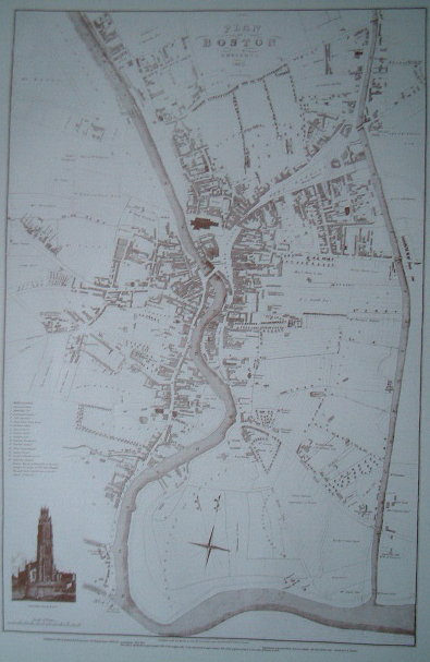
Map of Boston – 1829
£7.50
Description
One of three maps of Boston available.
Surveyed by John Wood, land surveyor of Scarborough and engraved by T. Gent of Edinburgh. Approximately 36.5cm (14.4″) x 55.2cm (21.7″).
Please note my apologies regarding the cost of postage on maps. Unfortunately, as I use cardboard rolls, to post them, the cost is quite high. The Post Office treat rolls as medium parcels! If you would prefer it to be folded – the postage will be significantly less but please email me prior to ordering so I can arrange a reduction in the postage charged.
Additional information
| Weight | N/A |
|---|---|
| Type | Prints |
| Author | Surveyed by John Wood |
| Publisher | Richard Kay Publications |
Related products
-
Horseshoe Bay
£13.32Select options This product has multiple variants. The options may be chosen on the product page -

Mystery and Mayhem in Darkest Lincolnshire
£12.99Select options This product has multiple variants. The options may be chosen on the product page -
Occasional Papers in Lincolnshire History and Archaeology No 11
£4.95Select options This product has multiple variants. The options may be chosen on the product page -
Admiral of New England – Captain John Smith and the American Dream
£5.99Select options This product has multiple variants. The options may be chosen on the product page
Reviews
There are no reviews yet.